Overnight strong storms are expected, which could bring gusty wind, hail and heavy rain to Southeast Texas
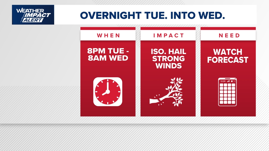
HOUSTON — The KHOU 11 News Weather Team is issuing an hourly Weather Impact Alert for Tuesday night into early Wednesday morning.
Strong thunderstorms with gusty wind, hail and brief heavy rain are possible from 8 p.m. Tuesday to 8 a.m. Wednesday.
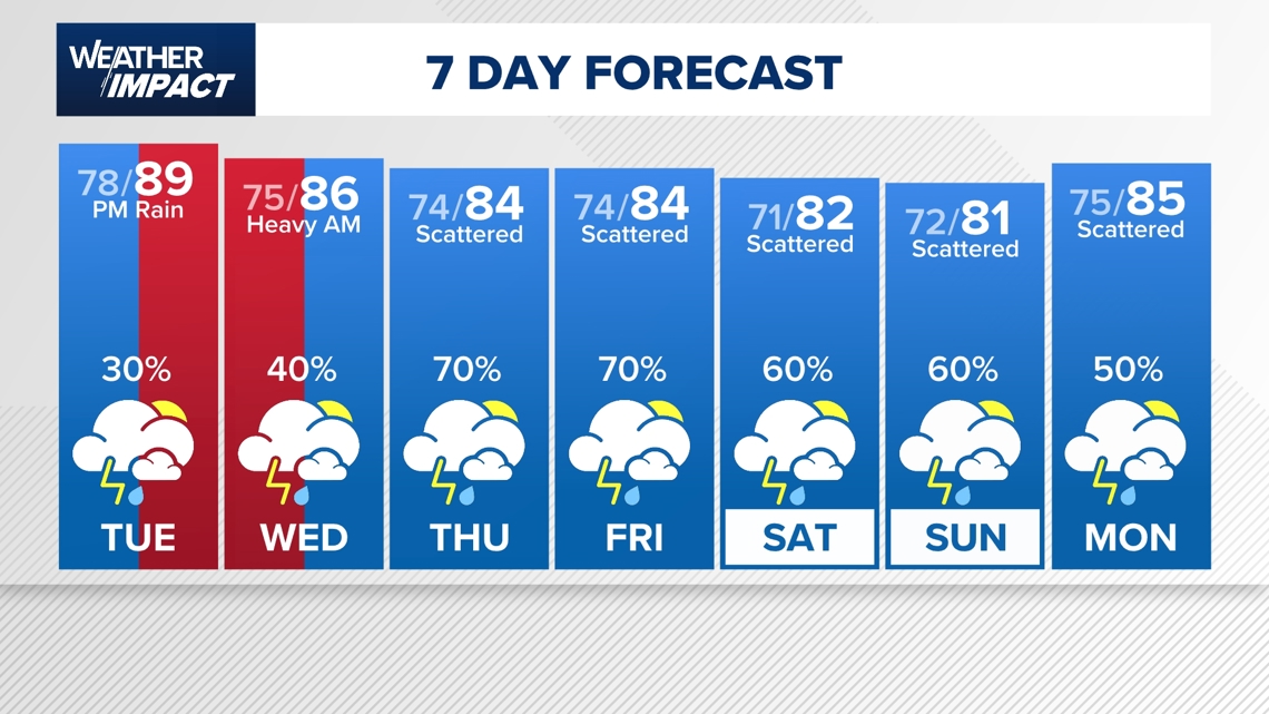
Daily rain chances will continue through the rest of the week and through the holiday weekend.
What to expect
Houston is heading into a much wetter weather pattern this week, with repeated rounds of rain and thunderstorms expected through Memorial Day weekend. The KHOU 11 Weather Team says the threat for localized street flooding will increase later in the week as multiple waves of storms move across Southeast Texas.
Monday is expected to stay relatively quiet compared to what’s ahead, with warm and humid conditions and only isolated afternoon shower chances. But rain chances begin ramping up Tuesday before a more active stretch settles into the region overnight Tuesday into Wednesday.
Storm chances increase Tuesday night into Wednesday
KHOU 11 Weather Team says the first significant round of storms is expected to arrive late Tuesday night and continue into early Wednesday morning. The system could bring heavy downpours, gusty winds and even some small hail to parts of the Houston area.
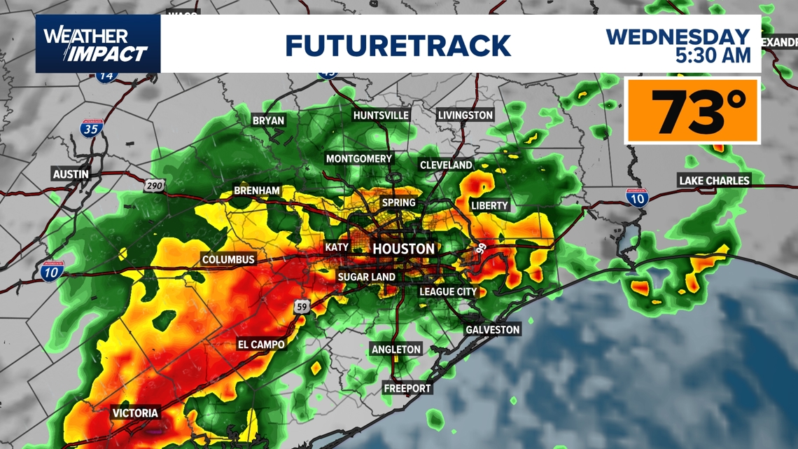
Meteorologists described the incoming setup as a “mesoscale convective system,” which could organize storms capable of producing stronger wind gusts as they move through Southeast Texas..
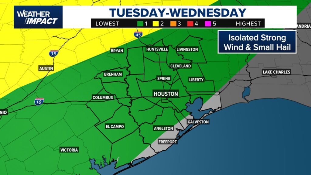
A Level 1 severe weather threat is in place for the Houston area from 11 p.m. Tuesday through early Wednesday morning. Higher severe weather risks are expected farther north near the Dallas-Fort Worth area.

The timing could create a messy Wednesday morning commute across the region.
Flooding concerns grow later this week
Rain chances remain elevated Thursday and Friday, with KHOU 11 Weather Team warning that repeated rounds of rain could lead to localized street flooding throughout the week
Current projections show many areas could receive 2 to 4 inches of rain by the end of the week, while isolated spots could see 6 to 7 inches.
Thursday currently appears to carry the highest flooding concern, especially for the northwestern parts of Southeast Texas. KHOU 11 Weather Team says the heaviest and most consistent downpours are expected that day.
A Level 2 flood threat has already been issued for northwestern cities and counties, while the Houston area remains under a Level 1 flood threat on Thursday.
Looking ahead
The unsettled weather pattern is expected to continue through Memorial Day weekend, with daily rain chances remaining in the forecast. The tradeoff for the wet pattern will be cooler-than-normal temperatures by the weekend, with highs expected to settle into the low 80s.
Counties we serve: Harris County (including Houston, Pasadena, Baytown), Fort Bend County (Richmond, Sugar Land, Missouri City), Montgomery County (Conroe, The Woodlands), Brazoria County (Angleton, Pearland, Alvin, Lake Jackson), Galveston County (Galveston, League City, Texas City), Liberty County (Liberty, Cleveland, Dayton), Walker County (Huntsville, New Waverly), Waller County (Hempstead, Prairie View, Waller), Polk County (Livingston, Corrigan), Chambers County (Anahuac, Mont Belvieu, Winnie), Wharton County (Wharton, El Campo), Washington County (Brenham), Matagorda County (Bay City, Palacios), Grimes County (Anderson, Navasota), Austin County (Bellville, Sealy), Colorado County (Columbus, Eagle Lake, Weimar), Trinity County (Groveton, Trinity).
Got a news tip or story idea? Email us at newstips@khou.com or call 713-521-4310 and include the best way to reach you.