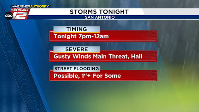
Gusty winds are the main threat
FORECAST HIGHLIGHTS
-
STORMS TO OUR SOUTH: Overnight storms near Corpus Christi pushing away
-
WARM/HUMID TODAY: Expect some clearing, with storms holding off until evening
-
STORMS ARRIVE AROUND SUNSET: 7PM-12AM timeframe, severe weather possible
-
MORE STORMS THIS WEEK: Additional rounds of storms through Saturday
FORECAST
TODAY’S TIMELINE
MORNING
-
Did you hear thunder overnight? It was part of a complex of storms that moved well south of San Antonio. These storms moved through Corpus Christi and have pushed into the Gulf. In the wake of this system, some clearing should occur later this morning.
MIDDAY-AFTERNOON
-
Warm, humid conditions take over. Any storm activity will hold off until later in the day. Only small chances for rain are expected for school pickup and after-school activities.
THIS EVENING-TONIGHT
-
A front, with a line of storms may arrive as early as 7pm. We’ll also be watching any storms that push in from the west along a dryline. These storms will be capable of producing powerful winds. We also cannot rule out hail up to the size of quarters, with the stronger storms. Rainfall totals of an 1″ or more may also occur. Storms should begin to push south of the area by midnight.
WEDNESDAY
After storms exit the area overnight, we should see quiet conditions for the first half of Wednesday. By the afternoon, the atmosphere will destabilize again. Isolated storms are possible. Another round of storms may push out of Mexico Wednesday night into Thursday morning. Should this happen, flooding would be a concern.
MORE STORMS THROUGH THE WEEKEND
Additional rounds of storms are possible through Saturday. This will add to flooding concerns. By Sunday and into Memorial Day, rain chances start to fall. If you have outdoor plans this weekend, continue to check back!
QUICK WEATHER LINKS
Copyright 2026 by TheTXLoop – All rights reserved.