
FORECAST HIGHLIGHTS
-
MORNING FOG POSSIBLE: Damp ground may lead to patchy low visibility at sunrise
-
QUIETER PATTERN AHEAD: Dry stretch builds in with more sunshine late week
-
WARMER WEEKEND: Highs climb into the upper 80s and low 90s under partly sunny skies
FORECAST
TODAY
Calmer conditions are expected heading into Thursday morning. Temperatures will gradually fall through the 70s before settling into the mid-60s by sunrise. With recent rainfall and lingering moisture near the surface, patchy fog may develop during the early morning commute.
THIS WEEKEND
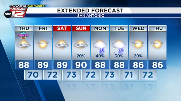
A drier weather pattern is developing as high pressure strengthens over Texas, limiting rain chances and allowing for more sunshine. Skies are expected to remain partly to mostly sunny both days, with afternoon highs climbing into the upper 80s and low 90s. Overnight lows will stay mild, generally in the upper 60s to lower 70s.
Humidity levels will remain manageable through the end of the week, although conditions may still feel muggy at times due to saturated ground from recent rains.
EXTENDED FORECAST
Looking ahead to the weekend and early next week, rain chances gradually return as a more active upper-level pattern develops across the region. Isolated showers and thunderstorms could begin to redevelop Sunday night into Monday, with rain chances increasing slightly into Tuesday. Current forecast guidance suggests only scattered coverage, with most locations expected to remain dry for extended periods.
QUICK WEATHER LINKS
Copyright 2026 by TheTXLoop – All rights reserved.