Sunday will be humid and warm, but daily storm chances begin Tuesday night
FORECAST HIGHLIGHTS
-
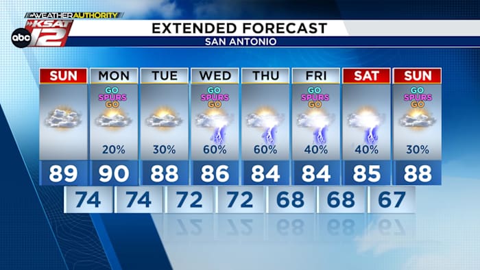
SUNDAY: Humid and warm, near 90°. 20% spotty evening rain
-
NEXT WEEK: Daily storm chances, beginning Tuesday night and lasting through Memorial Day Weekend
-
WATCHING FOR: Hail, Street Flooding.
-
ACTIONS: Check forecast daily
-
RAINFALL POTENTIAL: 1″ to 3″, cumulatively
-
FORECAST
SUNDAY
Noticeably more humid than Saturday. Mostly cloudy with some peeks of sunshine in the afternoon. Near 90°. There is a small chance for a shower or storm in the evening, but the chance is only 20%.
NEXT WEEK
Our weather pattern next week will be unsettled. Rounds of energy and a slow-moving cool front will keep storms in the forecast daily, mainly starting Tuesday night. Timing and placement of storms is difficult to know at this point, but wherever storms set up, we’ll have the ingredients for strong or severe storms AND storms capable of street flooding. This unsettled pattern looks to last through Memorial Day Weekend, too.
BOTTOM LINE: It will be a week to pay close attention to the weather. Check our forecast daily. Make sure you have the TheTXLoop Weather Authority App.
The good news? We are still in a multi-year drought and need rain. From Tuesday night through the weekend, many neighborhoods will have collected 1″ to 3″ of much-needed rain.
QUICK WEATHER LINKS
Copyright 2026 by TheTXLoop – All rights reserved.