Cooler weather by the evening, small chance of a storm
FORECAST HIGHLIGHTS
-
COLD FRONT: Arrives by early afternoon, cooler, breezy by evening
-
RAIN CHANCE: Low odds today of a storm, severe weather can’t be ruled out
-
CONTINUED RAIN CHANCES: Thursday through Saturday
FORECAST
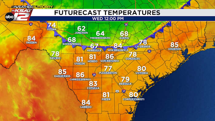
COLD FRONT TODAY
A potent, early May cold front will move through the area today. The timeframe for its arrival has moved up, with changes expected in San Antonio during the early afternoon hours. We’ll reach a high temperature in the mid-80s around lunchtime, before temperatures dip into the 70s by late afternoon. Northeast winds are forecast to be breezy.
RAIN CHANCE
The front will bring a chance for a storm or two. While coverage will be limited (20%), should a storm develop, severe weather is possible. The risk for severe weather will end once the front passes by.
MORE RAIN CHANCES
-
THURSDAY: Behind the front, passing disturbances will keep a few showers and a storm or two in the forecast. Rain chances sit at 30%.
-
FRIDAY/SATURDAY: An upper level low will move west to east across Texas. This will increase our rain chances to 40% Friday afternoon into the day on Saturday. Activity will be scattered. Severe weather cannot be ruled out. Rain chances end Saturday evening.
MOTHER’S DAY
Sunday calls for mostly sunny skies and warm conditions. Highs will be near 90.
QUICK WEATHER LINKS
Copyright 2026 by TheTXLoop – All rights reserved.