The pattern remains active into the weekend
WATCH LIVE RADAR ABOVE
FORECAST HIGHLIGHTS
-
RAIN: Rain, with some thunder and lightning will affect San Antonio through sunrise
-
ISOLATED PM STORMS: We’ll get a break, with isolated storms returning later today
-
ANOTHER ROUND TONIGHT?: It’s possible. We’ll watch what unfolds to our west
FORECAST
EARLY MORNING COMMUTE
Prepare for showers and a few non-severe storms this morning. This will affect San Antonio through roughly sunrise.
REST OF TODAY/TONIGHT
We’ll see a break thereafter, with quiet conditions into the early afternoon hours. Keep the umbrella in the car. Isolated storms are forecast to redevelop late in the day. We may also another round of storms tonight. As it has been, street flooding will be possible.
FRIDAY AND MEMORIAL DAY WEEKENED
-
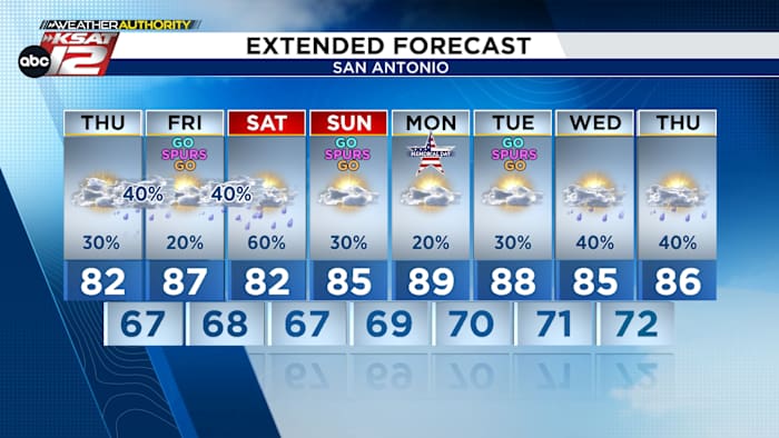
FRIDAY: After a chance for morning storms, most of Friday is forecast to be relatively quiet. Expect partly cloudy skies and warm temperatures.
-
SATURDAY: Energy from the west will enhance rain chances yet again on Saturday (60%). A messy upper level setup will make it tough to pinpoint timing and amounts. Clouds and rain will make for slightly cooler temperatures.
-
SUNDAY: Quieter weather is forecast for Sunday, with the sun making a return. Highs will reach the mid-80s
-
MONDAY: Only isolated storms are expected (20%). Temperatures will reach to near 90.
QUICK WEATHER LINKS
Copyright 2026 by TheTXLoop – All rights reserved.