FORECAST HIGHLIGHTS
-
THURSDAY: Back to 100°
-
FRIDAY & WEEKEND: Mid 90s, Isolated Downpours
-
TROPICAL DEVELOPMENT? Probably not … 10% chance of through Friday
FORECAST
TEMPERATURES
We’ve had only three triple digit days so far this year, but Thursday is likely to be our fourth. Mid 90s are expected Friday through the weekend, which is average for this time of year, as our next chance of rain arrives.
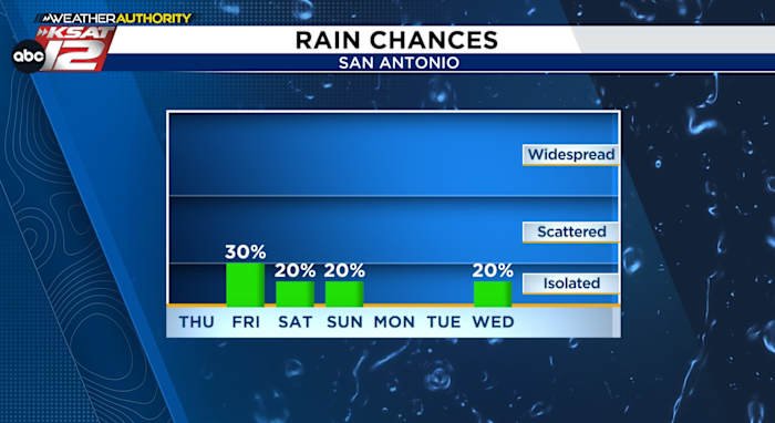
RAIN CHANCES
An upper-level system will bring a bit of rainmaking energy to our area by Friday, but don’t expect much in terms of coverage or accumulation. Most of the rain should be along the Gulf Coast where an inch or so is likely.
That upper-level system is currently near Cuba and will arrive with deep atmospheric moisture, so rogue downpours are possible Saturday and Sunday – especially in the afternoon. Where those showers pop-up, a quick inch of rain is possible, but flooding is not likely at this time.
TROPICAL DEVELOPMENT
Just a 10% chance of development in the Gulf over the next few days, but as of now, no model guidance suggests a tropical depression or tropical storm.
NEXT WEEK
Sunny and warm Monday and Tuesday, but another weak push of upper-level energy could bring isolated rain chances back into the picture Wednesday.
QUICK WEATHER LINKS
Copyright 2025 by TheTXLoop – All rights reserved.