FORECAST HIGHLIGHTS
-
DRY AFTERNOON: Rain finally exits for a humid afternoon
-
RAIN THIS WEEKEND: Isolated (20%) Saturday and Sunday
-
NEXT WEEK: Rain chances Monday and Tuesday
FORECAST
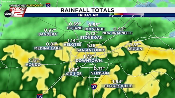
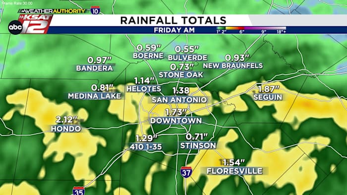
The end of May has been good to us. Heavy rainfall has put a dent (a small one) in our drought situation.
FRIDAY
Storms from West Texas made its way to San Antonio as the upper level flow will take that activity and push it south and east towards our area tonight, along with a weak cold front.
AFTERNOON
Once the storms, along with a weak front, pass us by, we’ll see quieter conditions for much of Friday. The one exception would be areas south of San Antonio which may see a few more isolated storms.
THIS WEEKEND
Saturday and Sunday will bring more cloud cover thanks to a potential tropical connection. A developing tropical system in the Pacific will move north along the coast of Mexico. Eventually, some of that tropical moisture will make a run at South Texas. Most of the deep moisture will remain south of us, but a few showers can’t be ruled out as a result. Otherwise, it’ll be warm and humid this weekend.
RAIN CONTIUES NEXT WEEK
The pattern continues to remain slightly unstable as daily rain chances continue. We’ll keep you posted on the chance of them becoming severe.
QUICK WEATHER LINKS
Copyright 2025 by KSAT – All rights reserved.
https://www.ksat.com/weather/2025/05/29/well-be-watching-for-another-round-of-storms-tonight/