STORY HIGHLIGHTS
-
RECORD HOURLY RAINFALL: On June 12, San Antonio had its highest hourly rainfall rate on record: 3.98 inches
-
RECORD DAY, TOO: The city received its 10th wettest day on record: 6.11 inches
-
WHY SO MUCH RAIN? Pattern of high atmospheric moisture, instability, weak shear and mesoscale storm dynamics drove rain event
SAN ANTONIO – The June 12 flooding in San Antonio broke records in more ways than one.
It was one of the deadliest in San Antonio, with 13 people killed after their vehicles were swept away by raging floodwaters. About 15 cars were swept away, and 11 people died along a roughly 1.5-mile stretch on the Northeast Side, near Loop 410 and Perrin Beitel Road.
Intense rainfall in just a short period of time resulted in San Antonio observing both its highest hourly rainfall rate on record (since 1934) and its 10th wettest day on record (since 1885).
In the aftermath of the deadly flood, the National Weather Service has recently released a detailed report on rainfall totals, records and data behind the storm system that “exacerbated the situation in San Antonio.”
Meteorology background: What resulted in ‘exceptionally efficient rainfall’
A pattern of high atmospheric moisture, instability, weak shear and mesoscale storm dynamics drove the June 11–12 event in South-Central Texas.
The result was a highly efficient rain-producing environment and a record-setting flash flood.
A slow-moving weather system called a trough — an area of low pressure in the upper atmosphere — was drifting eastward across Texas.
Normally, these systems move along, but this one was stuck in place because of a blocking pattern, where a high-pressure system sat just to the north. This combination kept the low over Texas for days, allowing tropical moisture from the Gulf to pour into the state.
Forecasts as early as June 7 warned of possible flash flooding, and national weather outlooks began highlighting the San Antonio area for excessive rain.
The atmosphere was primed for heavy rain.
By the night of June 11, the setup over South-Central Texas became extremely favorable for heavy rain. Weather balloons and high-resolution computer models showed a thick layer of very humid air over the region.
The atmosphere was warm up to about 15,000 feet. That matters because warm clouds make rain more efficiently than cold ones that contain ice.
The air was humid from the surface up through the middle levels of the atmosphere, meaning there were no dry pockets to weaken the storms or reduce rainfall. The atmosphere had just the right amount of energy to build strong, but not overly tall, thunderstorms — ideal for squeezing out a lot of rain.
Just before the heaviest rain started, cooler air from earlier storms in the Hill Country moved toward San Antonio and ran into warmer, wetter Gulf air near the Balcones Escarpment. That clash helped ignite new thunderstorms right over the city.
Those storms continued to form and move over the same areas, a term called training. At the same time, a low-level jet — a fast-moving stream of air a few thousand feet above ground — kicked in and delivered even more moisture to feed the storms.
Between 2:51 and 3:51 a.m. on June 12, the city’s airport recorded 3.98 inches of rain — more than it usually gets in an entire month.
That single hour broke the record for the most rain ever recorded in one hour at that location since modern measurements began in the 1990s. In just two hours, 5.29 inches of rain fell, overwhelming roads and drainage systems.
Rainfall totals break records
San Antonio saw its highest hourly rainfall rate since 1934 and its 10th rainiest day since 1885 on June 12.
It was also the city’s second-wettest June day on record and the wettest day since May 25, 2013.
The highest hourly rainfall amount measured 3.98 inches, while the total rainfall for the day was recorded at 6.11 inches.
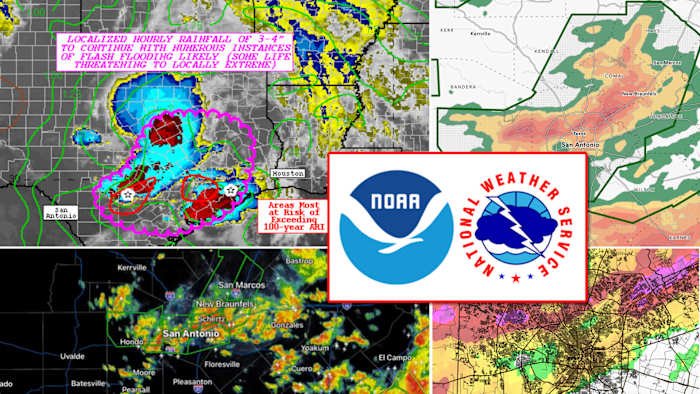
According to the report, the heaviest rainfall, measuring 6 to 8 inches, fell from northeastern Medina County through Leon Valley and the San Antonio International Airport in Bexar County.
It also extended north along Interstate 35 to New Braunfels in Comal County.
The band of heavy rain closely followed the Balcones Escarpment, a steep geological fault zone in Central Texas that separates the higher Hill Country from the lower Coastal Plains, the report states.
“Recent research has shown that while this terrain feature ‘does not directly affect the occurrence or magnitude of precipitation in the region’, it can ‘affect the spatial distribution of the accumulated rainfall in a small but consistent way—namely, by shifting the axis of heaviest precipitation slightly to the northwest,’” the report states.
In this case, the heaviest rain fell just north and northwest of the escarpment’s edge.
Beyond the heaviest rain area, rainfall totals of 1 to 3 inches were widespread along the I-35 corridor south of Austin and over the Coastal Plains.
Other areas experienced significant rainfall amounts, according to the report, including the New Braunfels Municipal Airport, which recorded its fifth wettest day since April 1998 with 5.10 inches of rain.
Highest hourly rainfall rates on record (since 1934):
-
June 12, 2025: 3.98 inches
-
May 25, 2013: 3.88 inches
-
June 3, 1988: 3.20 inches
-
July 1, 2002: 3.17 inches
-
Sept. 25, 1946: 2.88 inches
-
Oct. 7, 1981: 2.83 inches
-
Oct. 17, 1998: 2.82 inches
-
Sept. 3, 2018: 2.80 inches
-
June 3, 1951: 2.71 inches
-
July 7, 1958: 2.67 inches
Rainiest days in San Antonio’s history (since 1885):
-
Oct. 17, 1998: 11.26 inches
-
May 25, 2013: 9.87 inches
-
July 1, 2002: 9.52 inches
-
Sept. 9, 1921: 6.83 inches
-
May 31, 1937: 6.82 inches
-
April 18, 1915: 6.78 inches
-
Sept. 26, 1973: 6.54 inches
-
May 5, 1993: 6.26 inches
-
June 3, 1951: 6.18 inches
-
June 12, 2025: 6.11 inches
NWS timeline
The NWS provided this timeline of key briefings, forecasts, watches and warnings issued by the agency:
June 7-June 10
-
Approximately 2 a.m.: NWS Weather Prediction Center highlights potential for excessive rainfall in South-Central Texas, possibly causing flash flooding. NWS outlooks a Level 2 of 4 risk (Slight) for rainfall exceeding flash flood guidance for parts of Central and South-Central Texas from June 11 to the morning of June 12.
June 9
-
3:28 p.m.: On social media, NWS Austin/San Antonio highlights potential heavy rain during the week, with the heaviest chances on June 11–12.
June 11
-
3:14 a.m.: WPC issues Level 3 of 4 risk (Moderate) for rainfall exceeding flash flood guidance in South-Central Texas. The Level 2 risk (Slight) was maintained for the San Antonio metro into the early morning of June 12.
-
10:40 a.m.: WPC expands the Level 3 risk area slightly south across South-Central Texas for rainfall exceeding flash flood guidance into the early morning of June 12.
-
1:50 p.m.: NWS Austin/San Antonio issues a Flood Watch for the Hill Country, I-35 corridor from Austin northward, and Coastal Plains from 7 p.m. June 11 through 7 p.m. June 12.
-
2:36 p.m.: NWS Austin/San Antonio sends Situation Report with forecast of isolated 6-inch rainfall and scattered flooding in northern Hill Country, I-35 corridor and Coastal Plains.
-
4:02 p.m.: NWS posts safety information on vehicle and nighttime flash flooding on the Austin/San Antonio social media pages.
-
7:37 p.m.: WPC expands the Level 3 risk area farther south to include the San Antonio metro, marking the first Level 3 risk day for San Antonio since May.
-
9:17 p.m.: NWS Austin/San Antonio expands Flood Watch southward to include the San Antonio metro.
-
9:34 p.m.: NWS Austin/San Antonio updates Situation Report, expanding Flood Watch southward due to new model guidance and trends, calling for increased weather awareness overnight. “There is a growing signal that storms with intense rainfall rates will develop farther south than previously thought. Stay weather aware overnight and into Thursday morning and push Turn Around, Don’t Drown messaging,” the alert said.
-
10:07 p.m.: WPC issues Mesoscale Precipitation Discussion on heavy rainfall and scattered flash flooding likely from slow-moving thunderstorms.
-
11:03 p.m.: NWS Austin/San Antonio posts radar update on social media showing increasing storm coverage with heavy rainfall and flooding risks overnight.
-
11:24 p.m.: NWS alerts media and partners of 1.26 inches of rainfall in 30 minutes near Government Canyon, with Flash Flood Warning forthcoming. Radar shows 4-5 inches per hour rainfall rates in northwest Bexar County.
-
11:29 p.m.: Flash Flood Warning issued for northwest Bexar County, parts of Blanco, Comal, Hays, Kendall and Medina counties until 4 a.m. on June 12.
June 12
-
12:02 a.m.: NWS sends the following alert to partners: “Rainfall rates have also increased in western Comal County. 3” of rain reported in Spring Branch in western Comal County, with a 5.5″ per hour rainfall rate. Flash Flooding imminent in western Comal County. Flood Advisory issued farther east into northern Bexar, eastern Comal, and Hays counties. Will monitor closely for any potential upgrade to warning. Seeing a few low water crossings in northwest Bexar County now closed due to flooding on BexarFlood.org.”
-
12:36-12:40 a.m.: Gauges show more than 2 inches of rain along Culebra Creek; Flood Advisory upgraded to Flash Flood Warning for northern Bexar, eastern Comal and Hays counties.
-
12:40 a.m.: Flash Flood Warning issued for northeast Bexar County, parts of Blanco, Comal, Hays and western Guadalupe counties until 5 a.m.
-
12:45 a.m.: NWS posts radar update noting scattered flash flooding in San Antonio metro, Comal and Hays counties; advises “Turn Around, Don’t Drown.”
-
12:59 a.m.: NWS informs partners of 3-5 inches of rain in northwest Bexar County over the past two hours; increasing closed low water crossings.
-
1:20-1:57 a.m.: NWS issues the following alert: “3.58” of rain measured now by gauge on Culebra Creek in northwest Bexar County. 3.60″of rain measured 5 miles SSW of Dripping Springs and 3.25″ along the Blanco River at Fischer Store Road” and “River Flood Warning coming for Leon Creek in San Antonio. Training of storms continues into northwest Bexar County. Flash flood threat is escalating. SAFD responding to water rescues.” NWS follows up with “Gauge at Culebra Creek in northwest Bexar County has now recorded 4.02” of rainfall. Gauge 5 miles SSW of Dripping Springs is at 3.91.″ Radar estimates 5-6″ of rainfall has occurred between Leon Valley, Helotes, and Government Canyon.”
-
1:47 a.m.: Flood Warning issued for Leon Creek at I-35 with flooding imminent on roads and bridges.
-
1:56 a.m.: Flash Flood Warning update adds rainfall rates of 1-3 inches in 30 minutes; isolated totals up to 7 inches possible.
-
2:09 a.m.: NWS alerts partners to escalating flash flood threat from eastern Comal into southern Hays and northern Guadalupe counties.
-
2:45 a.m.: NWS posts radar update of ongoing dangerous flash flooding in San Antonio metro; urges caution, especially at night.
-
2:47 a.m.: NWS warns of ongoing dangerous flash flooding from San Marcos to New Braunfels and northwest San Antonio. Some places had already received 3-7 inches of rain.
-
2:55 a.m.: WPC issues Mesoscale Precipitation Discussion highlighting “very heavy rainfall” of 3-4 inches per hour leading to numerous flash flooding instances, some life-threatening.
-
3:03 a.m.: NWS alerts partners to “training of storms” in northeast Bexar, southern Comal, northern Guadalupe counties; flash flood threat escalating.
-
3:17 a.m.: Flash Flood Warning issued for southwestern Bexar County, including the Leon Creek area, and east central Medina County until 8:30 a.m.
-
3:58 a.m.: Another Flash Flood Warning issued for eastern Bexar County, including an overlap of the original Flash Flood Warning across the Beitel Creek area, and parts of Guadalupe and Wilson counties.
-
4:01 a.m.: NWS reports 40 low water crossings closed due to flooding in Bexar County.
-
4:06 a.m.: NWS posts social media warning about dangerous flash flooding and advises “Turn Around, Don’t Drown.”
-
4:15 a.m.: Emergency calls report vehicles stranded on Loop 410 near Perrin Beitel Road. Fifteen vehicles were swept into Beitel Creek; 10 people were rescued by SAFD, and two were self-rescued.
-
4:31 a.m.: NWS says SAFD is responding to 11 water rescue calls; urges caution during morning commute.
-
4:38 a.m.: NWS posts radar update of flash flooding in San Antonio metro area and surrounding counties; repeats flash flood safety message.
-
4:44 a.m.: NWS shares media reports of dangerous flash flooding and submerged vehicles in Bexar and Comal counties; safety message reiterated.
-
4:58 a.m.: NWS reports Leon Creek at Loop 410 rising sharply 13 feet with flow over 41,000 CFS.
-
5 a.m.: NWS posts graph of sharp rise in Leon Creek at Loop 410.
Leon Creek at Loop 410 near Leon Valley in the San Antonio area has risen sharply 13 feet and has over 41,000 cubic feet of water per second flowing through it. pic.twitter.com/BOgVw2KM99
— NWS Austin/San Antonio (@NWSSanAntonio) June 12, 2025
-
6:05 a.m.: NWS said the heaviest rainfall and flash flood threat shifts to the Coastal Plains. A Flash Flood Warning was issued for Dewitt and parts of Gonzales, Karnes and Lavaca counties until 11 a.m.
-
7:22 a.m.: NWS posts radar update showing storm shifting south.
-
8:22 a.m.: Flash Flood Warning extended until 9:30 a.m. for southwestern Bexar County, including Leon Creek and parts of Medina County.
-
8:47 a.m.: Flash Flood Warning extended until 10 a.m. for central and eastern Bexar County, including Beitel Creek and portions of Guadalupe and Wilson counties.
Drought monitor
The June 12 flood happened during a period of extreme to exceptional drought.
The drought intensity improved by one to two categories in some areas, according to the report.
However, an exceptional drought — the most severe category — remained in many parts of the northwest and west sides of Bexar County as of June 17.
The U.S. Drought Monitor displays the occurrence and intensity of drought.
The map uses six classifications:
-
Normal conditions
-
Abnormally dry (D0), showing areas that may be going into or are coming out of drought
-
Moderate (D1)
-
Severe (D2)
-
Extreme (D3)
-
Exceptional (D4)
Coverage on June 12 floods:
Copyright 2025 by TheTXLoop – All rights reserved.