Heavy rain and storms moved through Southeast Texas Friday.
HOUSTON — After a day of soaking rains and travel headaches, conditions across Houston are improving. The worst of the weather is gradually pushing out.
Friday saw widespread street ponding, particularly along entrance ramps, feeder roads and low-lying spots, slowing traffic and reducing visibility.
At Bush Airport, unusually cool temperatures in the low 60s combined with steady rain and gusty north winds led to delays. Across the region, temperatures hovered in the upper 50s to low 60s, which is roughly 13 degrees cooler than the day before, creating a feel more typical of early November than the first day of May.
Even with all the rain, bayous and drainage systems handled the heavy rainfall effectively.
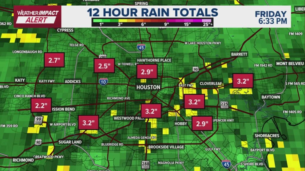
Rain totals were significant but manageable, with most areas along the I-10 corridor picking up between 1.5 and 3 inches. Some isolated spots saw higher amounts, including up to 5 inches in northwest Harris County and around 4 inches in the Spring and Kingwood areas. While the rainfall covered a large area, sending trillions of gallons into the bayou system, waterways like Spring Creek, Cypress Creek and Buffalo Bayou remained within their banks. Only a couple of trouble spots, including Langham Creek near Clay Road and Mound Creek in Waller County, approached bankfull levels, prompting warnings to stay clear overnight.
The good news arrives just in time for the weekend. As a cold front pushes through overnight, skies will clear and usher in an unusually beautiful start to May. Saturday morning will begin cool, with temperatures around 55 degrees, followed by sunshine, low humidity and afternoon highs in the low to mid-70s. Sunday brings another pleasant start in the mid-50s, with highs climbing into the upper 70s under clear skies — conditions that are rare for early May in Southeast Texas.
Looking ahead, the pattern remains favorable early in the week before shifting again. Monday and Tuesday stay warm but comfortable, with highs in the low to mid-80s and continued low humidity. A broader weather pattern featuring a dip in the jet stream is expected to bring cooler-than-normal temperatures and increased rain chances back to Houston by midweek and into next weekend, continuing a trend of wetter conditions that is helping chip away at drought concerns.
What to expect over the next few days:
- Friday night: Showers taper off by late evening; rain ends before midnight
- Saturday: Morning low near 55; sunny, dry, breezy; high around 71
- Sunday: Cool start near 56; sunny skies; high in the upper 70s
- Monday: Beautiful weather continues; low 57, high around 82, low humidity
- Tuesday: Slightly warmer; high near 84, still comfortable
- Wednesday–Friday: Increasing clouds with daily rain chances returning
- Next weekend: Continued cooler-than-normal temperatures with a wetter pattern settling in
Counties we serve:
Harris County (including Houston, Pasadena, Baytown), Fort Bend County (Richmond, Sugar Land, Missouri City), Montgomery County (Conroe, The Woodlands), Brazoria County (Angleton, Pearland, Alvin, Lake Jackson), Galveston County (Galveston, League City, Texas City), Liberty County (Liberty, Cleveland, Dayton), Walker County (Huntsville, New Waverly), Waller County (Hempstead, Prairie View, Waller), Polk County (Livingston, Corrigan), Chambers County (Anahuac, Mont Belvieu, Winnie), Wharton County (Wharton, El Campo), Washington County (Brenham), Matagorda County (Bay City, Palacios), Grimes County (Anderson, Navasota), Austin County (Bellville, Sealy), Colorado County (Columbus, Eagle Lake, Weimar), Trinity County (Groveton, Trinity).