FORECAST HIGHLIGHTS
-
VERY HUMID: Thanks to recent rains, humidity levels remain high
-
MORE JUNE-LIKE: Textbook June week, hot, humid, mostly dry
-
RAIN?: Only low chances later this week
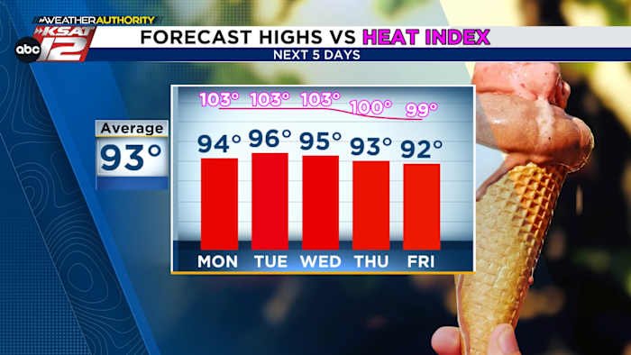
FORECAST
We’ve seen quite the stretch of busy weather. Now, we fall back into a more typical June pattern. That doesn’t mean we’ll be completely rain-free. Here’s what to expect this week.
TODAY
Sure, high temperatures will be near average (low-to-mid 90s), but that doesn’t mean it won’t be sweltering. Recent rains, including last night’s, have left plenty of moisture in our soils. That, combined with a southeast breeze, translates to thick humidity levels. Heat index values top 100° this afternoon. A stray shower can’t be ruled out, but is unlikely.
NEXT FEW DAYS
The summer heat high will try to nudge in from the west, cutting off rain chances and bringing temperatures up a bit Tuesday and Wednesday.
SMALL RAIN CHANCES
Later this week, we begin to watch the “westerlies”. That happens this time of year when the east to west movement of activity, opposite of what we usually see and typically seen in the tropics, shifts north into parts of Texas. This will bring a disturbance into South Texas and offer small chances of rain starting Thursday and continuing into the weekend.
QUICK WEATHER LINKS
Copyright 2025 by TheTXLoop – All rights reserved.