AUSTIN (KXAN) — Central Texas experienced the wettest start to July on record with historic and deadly rainfall since the beginning of July.
July is typically our second driest month of the year with less than two inches of rain falling in the month during a typical July.
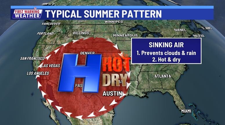
A common summer pattern would place high pressure either on top of Texas or to our west keeping us hot and dry thanks to sinking air that keeps clouds and rain at bay.
This year, June, which is the first month of meteorological summer, was hot and dry. It was our 15th hottest June on record and 22nd driest on record with only 0.85″ of rain in a month that usually receives more than three inches.
Pattern flip in July
The very end of June into the first two weeks of July saw a notable pattern change as high pressure drifted west over the southwestern U.S. with another area of high pressure setting up well to the east of us.
The result opened the door for tropical moisture from the remnants of Tropical Storm Barry to enter Central Texas over the July 4 weekend, followed by additional rounds of rain returning for the second weekend of July.
While the graphic simplifies things, the lack of high pressure allowed for less sinking air, which allowed more lift for rain to develop and an open door for systems to arrive here and stay here with no strong steering flow to kick storms out.

The result was one of the wettest Julys on record, even if it doesn’t rain the rest of the month.

Tragically, all this rain was responsible for deadly flash flooding responsible for killing so many people in the Hill Country and parts of the northwestern Austin metro.
Drier pattern coming
There are signs that our two-week pattern of almost daily rain and storms will come to an end very soon.
High pressure to our east will build westward into Texas and cut off rain chances with the exception of some very limited sea breeze showers.

The extended rainfall outlook from the Climate Prediction Center put a near-normal or drier than normal outlook over much of the area.

The temperature outlook leans toward a likely warmer than average end to July. A reminder that average is middle and upper 90s this time of year.

As always, though, we’ll have to watch the tropics for additional development that may sneak in.
In-Depth: How rain will impact the rest of summer
All the rain will have an impact on prior expectations of a very hot summer.
Wet soil will slowly dry out, which should make for more humid days as the sun’s energy gradually evaporates that soil moisture into the air.

Higher humidity levels will keep nighttime low temperatures up, but also will help prevent high temperatures from reaching triple digits as frequently as a summer with drought. The flip-side of this is that the higher humidity will make it “feel” hotter and push those heat index values up.
The wet soil will, at least temporarily, lower our wildfire risk.