FORECAST HIGHLIGHTS
-
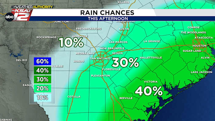
ISOLATED DOWNPOURS: Possible today, tomorrow (30%)
-
TIMING: Mainly midday through sunset
-
WHERE?: Best odds are along and east of I-35
FORECAST
Since Monday of last week, San Antonio’s high temperature has either been 91, 92, or 93. Talk about consistency! Today won’t be any different in that regard. However, we will bring rain chances up slightly this afternoon.
ISOLATED DOWNPOURS
Showers and a storm or two will develop along the coast later this morning, as weak spin in the atmosphere shoves some slightly better moisture onshore. These downpours will attempt to move inland towards San Antonio this afternoon. Bottom line: some of us will have to dodge some rain. It’ll be brief and street flooding is not anticipated, with rain totaling less than 0.50″ for those lucky enough to see it. Expect a similar setup on Wednesday.
AVOIDING THE EXTREME HEAT
While it is hot and sticky, we have been lucky enough to avoid the ‘heat dome’. It currently sits along the East Coast, where temperatures will be dangerously hot this afternoon. It’s worth noting that San Antonio will be cooler than most of the major cities in the Northeast.
CONSISTENCY
Through the weekend, you won’t see much change to the forecast. Heat, humidity, and a few showers continue.
QUICK WEATHER LINKS
Copyright 2025 by TheTXLoop – All rights reserved.