FORECAST HIGHLIGHTS
-
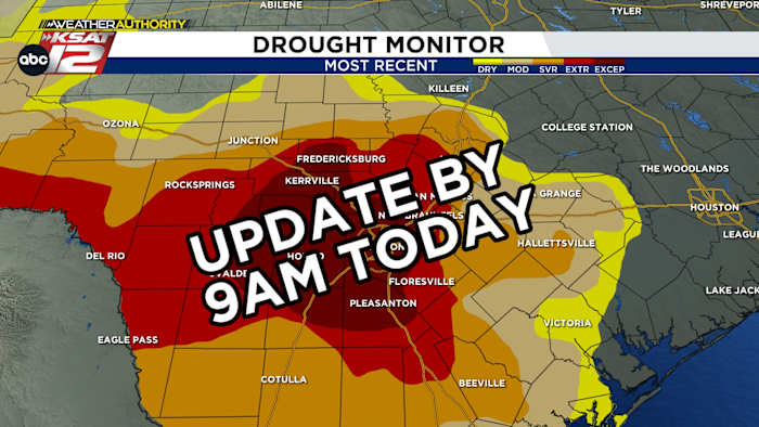
DROUGHT UPDATE: Expected by 9am today
-
BRIEF, STRAY SHOWER: Possible today, mainly SE of SA
-
HOTTER IN DETROIT: Heat high shifts NE, Detroit to be hotter than SA
FORECAST
While we cruise through a fairly uneventful stretch in the forecast, we’ll be paying close attention to what the rains early in the month mean for our drought situation. The drought monitor is forecast to be released later this morning.
WHAT IS THE DROUGHT MONITOR?
The U.S. Drought Monitor is a map released every Thursday, showing where drought is and how bad it is across the U.S. and its territories. Drawn by hand, it takes into account several factors, including soil moisture, lake levels, and rainfall totals. This should give us a good idea of how much recent rainfall helped our situation. Check back for an update.
TODAY’S FORECAST
The current setup calls for consistent weather, meaning each day over the next 7 days will be very similar. Morning clouds will be followed by partly cloudy skies. A few brief, very isolated showers are possible across the coastal plains. Otherwise, it’ll be hot and humid.
DETROIT HOTTER THAN SA
The infamous heat high will move from parking out over the desert southwest to moving well to our east and northeast. While this transition won’t have much affect on us, it is going to bring some serious heat to the Midwest and Great Lakes region. By the weekend, those in Detroit, Indianapolis, and St. Louis will likely see warmer temperatures than San Antonio.
QUICK WEATHER LINKS
Copyright 2025 by TheTXLoop – All rights reserved.