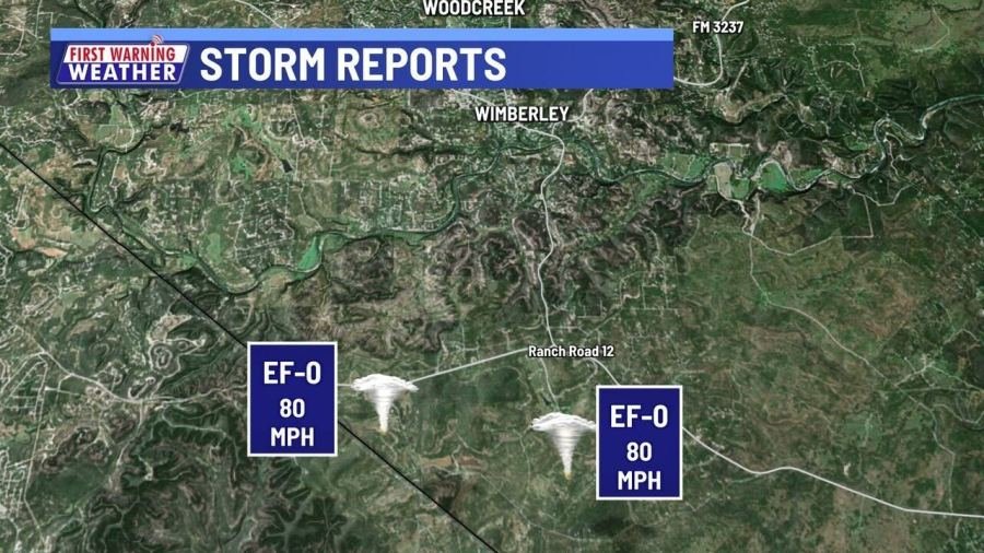
AUSTIN (KXAN) – The National Weather Service has released the details for the Hays County tornadoes, their survey team confirming that the damage sustained south of Wimberley was the result of not one, but two EF-0 tornadoes.
The tornadoes touched down very close to each other, the first being at 1:02 a.m. and the second at 1:06 a.m. The damage associated with these EF-0 tornadoes included fallen tree limbs, broken fences and shingles blown off roofs.
Hays County Tornado Facts
Tornado #1 southwest Hays County:
- Rating: EF-0
- Estimated Peak Wind: 80 mph
- Fatalities: 0
- Injuries: 0
- Path Length: 1.40 miles
- Path Width: 50 yards
- Start Time: 01:02 AM CDT
- Start Location: 4 SSW Wimberley / Hays County / TX
- End Time: 01:05 AM CDT
- End Location: 4 S Wimberley / Hays County / TX
Tornado #2 southwest Hays County:
- Rating: EF-0
- Peak Wind Speed: 80 mph
- Fatalities: 0
- Injuries: 0
- Path Length: 0.59 miles
- Path Width: 75 yards
- Start Time: 01:06 AM CDT
- Start Location: 5 S Wimberley / Hays County / TX
- End Time: 01:08 AM CDT
- End Location: 5 SSE Wimberley / Hays County / TX
At least one of the Hays County tornadoes were doppler radar confirmed, both touching down south of Wimberley. Each of the tornadoes were short lived with the latter one creating the most damage.

The winds of both tornadoes reached 80 mph, downing tree limbs and resulting in damage to local homes. According to the NWS, the most damage was recorded just north of the Teton Circle and Appalachian Road. There were no injuries or fatalities reported.
In Depth: Tornado confirmed within minutes using radar technology
The NWS Austin/San Antonio office had released a tornado warning for Hays County at 1:05 a.m., and the existence of a tornado was quickly confirmed using the correlation coefficient.

A tornado’s presence can be confirmed in an area through the correlation coefficient by what’s called tornadic debris signature. When a tornado lifts debris, the radar picks it up and the varying sizes of debris create a drop in the CC value. This drop can create an image like the one above, and can be useful in determining the presence of a tornado before it’s even been reported.