Flooding is ongoing in areas around San Antonio
WATCH LIVE COVERAGE IN VIDEO ABOVE
ACTIVE ALERTS
-
Flash Flood Warning until 9 am for Bexar,Guadalupe, Wilson County
-
Flash Flood Warning until 7:00am for Medina County
-
Flood Advisory until 10 am including the followingcounties, Bexar, Caldwell, Comal, Guadalupe and Hays.
-
Flood Watch through Thursday evening for Bandera, Bexar, Blanco, Caldwell, Comal, De Witt, Gillespie, Gonzales, Guadalupe, Hays, Karnes, Kendall, Kerr, Lavaca, Llano, Medina and Wilson.
-
Flood Warning for the San Antonio River near Elmendorf.
FORECAST HIGHLIGHTS
-
FLOODING RAIN: Up to 6″ of rainfall has fallen in San Antonio
-
SEVERE POSSIBLE: Severe risk is going down, flooding risk is rising
-
TURN AROUND: Several roads are flooded, please avoid low water crossings
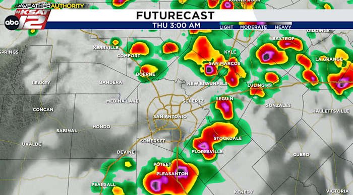
FORECAST
RAINFALL TOTALS SO FAR
-
San Antonio Airport: 6.05″
-
Balcones Heights: 4.36″
-
New Braunfels Airport: 4.99″
-
Castroville: 3.06″
-
Roosevelt Parl: 3.14″
-
Cibolo: 4.29″
-
Shavano Park: 3.01″
MORNING COMMUTE
Storms have trained over the northwest side of SA and that means several roads are impassable. Storms will continue for several more hours and slowly spread south across the rest of the city. I-35 has also been hit with heavy rain, meaning morning commutes will be very slow. Please take caution or try to leave later. The storms should be winding down by 8am.
THURSDAY THROUGH SUNDAY
Thursday afternoon looks quiet and the upper-low, which has been making the recent storms, will begin to slowly move away from us. That means rain chances will come down. Still, we’ll have a shot at isolated storms through the weekend. The flow is such that we’ll also need to keep an eye on any clusters of storms that make a run at San Antonio.
QUICK WEATHER LINKS
Copyright 2025 by TheTXLoop – All rights reserved.