AUSTIN (KXAN) — As rounds of storms and the threat for flash flooding continue on and off this week, it could be that the health of our lakes and our water supply for the summer rests on how much rain falls over the next few days.
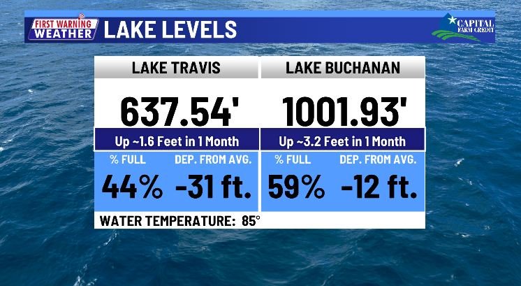
Lake Travis and Lake Buchanan have seen modest rises over the last few weeks. Lake Travis is up roughly 1.5 feet in the last month, and Lake Buchanan is up a little over three feet in the last month (as of Monday evening’s lake levels).
Typically, spring rain continues into at least the first half of June before generally tapering off and setting us up for our second driest month of the year we call July. August isn’t usually that wet either, but not one of our driest months.

This is why the rain and storms this week could be pivotal, as it could be the wettest period we see in several weeks or even months.
What it takes to fill the lakes
Heavy rain alone does not fill our lakes. You need rain to first saturate the soil before it runs off into the streams, creeks, and rivers that feed Lake Travis and Lake Buchanan. A wetter-than-normal May has helped moisten our soil, even if it’s not quite saturated yet.

This is setting us up for more runoff into the lakes as long as the rain falls in the “right places” this week.
For that, you need rain to fall into the water basins that feed Lake Travis and Lake Buchanan.

What will happen to lake levels in the coming months?
LCRA releases its lake level projections under various scenarios at the beginning of each month. These account for what has happened to the lakes during the prior months to create a starting point for what could happen next.

These various scenarios are separated into percentiles, with the “Median Conditions” (50th percentile) representing local weather conditions where half of the years have been wetter and half of the years have been drier.
The 25th percentile or “Wet Conditions” represents an amount of rain where only 25% of years had more rainfall, and the 99th percentile represents an amount of rain where only 1% of years were drier.
You can see that the scenario of “Median Conditions” keeps the combined storage of both lakes generally flat with only a little dip through the summer, with some rises into the fall.
The “Wet Conditions” scenario even has a summer dip, but still brings the combined storage over the 1.1 million acre-feet mark by the beginning of July.
Drier scenarios bring the combined storage below the levels with which we entered May 2024.
Why the dip in the summer?
According to LCRA, irrigation in the summer can account for ~70% of a home’s water use. Even under some of the wetter scenarios, it’s hard for it to rain enough to mitigate the additional water we’re using in the summer. Of course, the more it rains in the summer, the less water we have to use anyway, but July isn’t exactly known for its cooling rains.
Critical rain this week brings a flash flood risk
While the threat of flash flooding this week brings a significant danger to those that encounter it, we rarely fill our lakes without some level of flooding.
The easiest way to reduce the threat of flash flooding where you are is to avoid driving through roads covered in water and keep an eye on nearby streams and creeks that may rise quickly during heavy rain.
Also, make sure you have a way to stay informed. Flash flooding kills every year, and a substantial percentage of flash flooding deaths occur in vehicles. Have a way to receive important weather alerts, even while driving, so that you know when conditions may be conducive for flash flooding.
Stay with the First Warning Weather Team as we track the risk this week.