
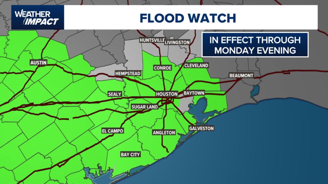
A Flood Watch remains in effect through Monday evening as repeated rounds of rain raise flooding concerns across Southeast Texas.
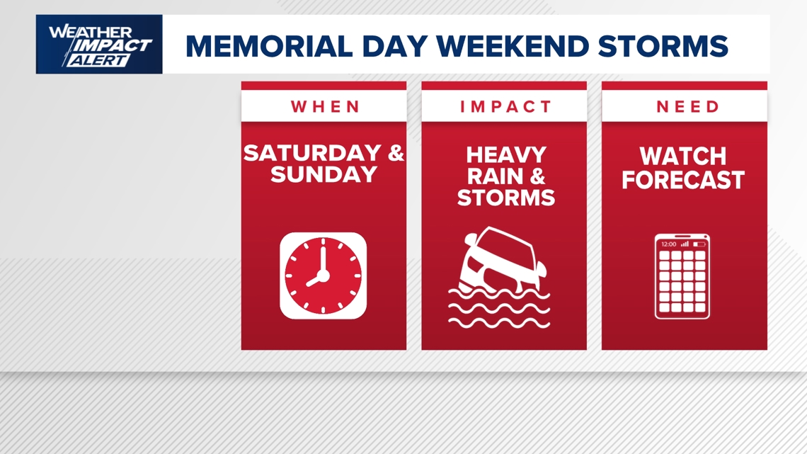
HOUSTON — The KHOU 11 Weather Team has issued a Weather Impact Alert for Saturday and Sunday as rounds of rain, heavy at times, could cause issues on roadways and flooding in some locations.
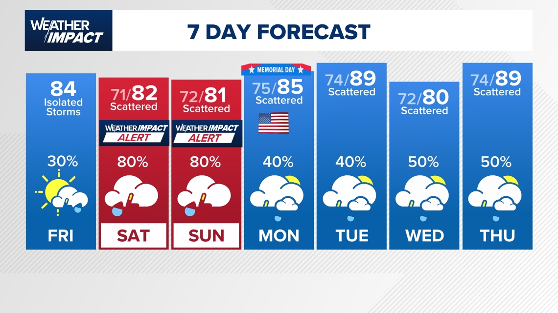
While Friday is expected to bring a temporary break from the rain with some sunshine and only isolated afternoon storms possible, conditions are expected to deteriorate heading into the holiday weekend.
The unsettled weather pattern is expected to persist through the next seven days and may continue beyond Memorial Day and even through the end of May as additional disturbances move across Texas.
The National Weather Service has issued a Flood Watch for most of the Houston area from now until Monday evening. This includes Harris, Fort Bend, Wharton, Brazoria, Galveston, Matagorda, and Jackson counties.
Rainfall rates could exceed 3 to 4 inches per hour in the strongest storms.
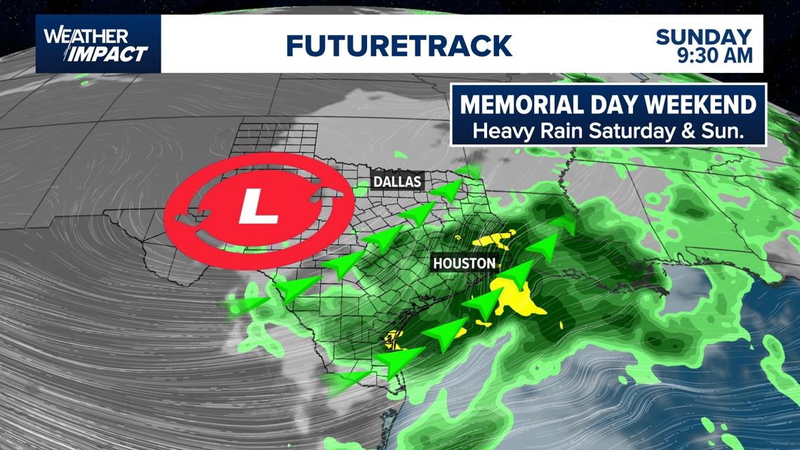
The weather setup involves the jet stream flowing over Southeast Texas and sending rounds of disturbances into the region on Saturday and Sunday. By Saturday afternoon, an approaching low-pressure system moving into Texas from the west is expected to increase rain and storm chances across the Houston area.
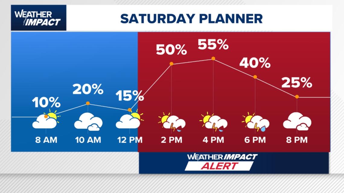
Forecasters say much of Saturday morning and even lunchtime could stay mostly dry, giving people a chance to get outdoor activities done before storms begin developing during the afternoon. Rain chances are expected to ramp up between about 1 p.m. and 2 p.m. Saturday, with widespread showers and thunderstorms likely by Saturday evening. Some storms could be strong.
The National Weather Service has placed Southeast Texas under a Level 2 flood threat for Saturday, part of a broader area that also includes cities like Austin and San Antonio. Meteorologists say one benefit of Friday’s drier weather is that it will allow some standing water to recede before heavier rain arrives over the weekend.
Latest weather model guidance has remained inconsistent on the exact timing and placement of the heaviest rain bands. “Training” storms — thunderstorms repeatedly moving over the same locations — could lead to higher rainfall totals and localized flooding.
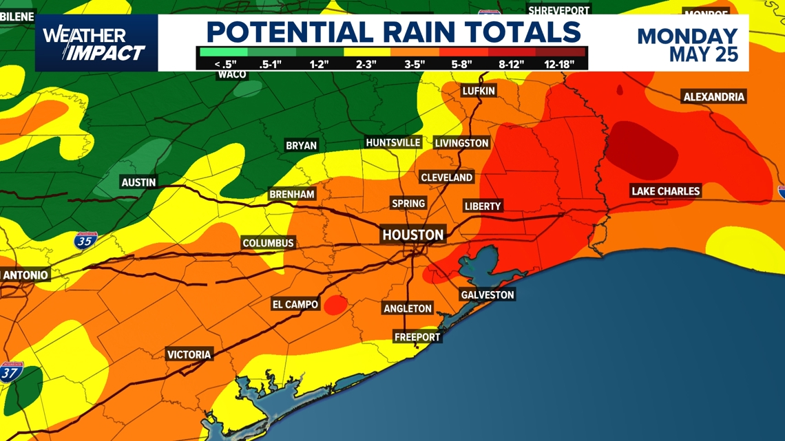
Additional rainfall accumulations could range between 3 to 5 inches across the Houston area through Memorial Day, though isolated locations could receive 5 to 8 inches of rain.
Saturday evening is expected to bring widespread heavy downpours that could lead to ponding on roads and high water in some locations. Another round of widespread rain may develop early Sunday morning, potentially impacting travel and outdoor plans through at least midday Sunday.
Rain could begin tapering off Sunday afternoon, though flooding concerns may linger even after the heaviest storms move out. Because of the flooding potential, both Saturday and Sunday have been designated as Weather Impact Alert days.
Memorial Day itself is now looking somewhat better, with lower rain chances expected Monday compared to the weekend. Scattered showers remain possible, but forecasters say conditions next week should gradually improve from the active weekend pattern.
Make sure you have indoor backup plans ready for Memorial Day weekend activities and stay updated on the latest forecasts, especially if traveling across Texas, where unsettled weather is expected statewide.
Counties we serve
Harris County (including Houston, Pasadena, Baytown), Fort Bend County (Richmond, Sugar Land, Missouri City), Montgomery County (Conroe, The Woodlands), Brazoria County (Angleton, Pearland, Alvin, Lake Jackson), Galveston County (Galveston, League City, Texas City), Liberty County (Liberty, Cleveland, Dayton), Walker County (Huntsville, New Waverly), Waller County (Hempstead, Prairie View, Waller), Polk County (Livingston, Corrigan), Chambers County (Anahuac, Mont Belvieu, Winnie), Wharton County (Wharton, El Campo), Washington County (Brenham), Matagorda County (Bay City, Palacios), Grimes County (Anderson, Navasota), Austin County (Bellville, Sealy), Colorado County (Columbus, Eagle Lake, Weimar), Trinity County (Groveton, Trinity).
Got a news tip or story idea? Email us at newstips@khou.com or call 713-521-4310 and include the best way to reach you.