The updated maps were released in February 2026, but experts said they would likely not be officially adopted for a few years.
HOUSTON — Dozens of experts gathered Thursday at Rice University to discuss FEMA’s newly proposed flood maps for Harris County and what the changes could mean for homeowners across the region.
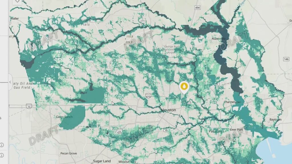
Officials and researchers at the one-day “Redrawing Risk” conference said the updated maps reflect increased rainfall rates, landscape changes and lessons learned from major storms, including Hurricane Harvey.
The proposed maps, released in February 2026, would place hundreds of thousands more families across Harris County within the 100-year and 500-year floodplains, according to experts at the conference.
Researchers showed side-by-side comparisons of the current flood maps and the proposed updates, with some areas seeing more significant changes than others.
“There’s certain parts of the county, particularly in the northwest and north of the county, where we’re seeing a lot of homes that are now designated as being in the floodplain,” Stephen Sherman, with Rice University’s Kinder Institute for Urban Research, said.
Experts also pointed to the Settegast neighborhood in northeast Houston as one of the areas expected to see some of the largest floodplain expansions.
The changes could have direct financial implications for homeowners.
“If you have a federally backed mortgage and your home is in a floodplain, you need to have flood insurance,” Sherman said.
Former Harris County Judge Ed Emmett, who is now with Rice University’s Baker Institute for Public Policy, urged residents to prepare.
“Number one, buy flood insurance, and that’s an easy thing to say, but depending on the neighborhood you live in, and the socioeconomic status, that may be easier said than done,” Emmett said.
Public policy experts acknowledged that some families may struggle to afford flood insurance or understand what steps to take right now, as it relates to the proposed map changes. They said community organizations, including Fifth Ward CRC and West Street Recovery, can help residents navigate available financial, educational and social support resources.
“I think really being plugged into some of these neighborhood associations and community organizations that can point them toward the resources, whether those resources be financial or educational or social support,” Michelle Smirnova, with Rice University’s Kinder Institute for Urban Research, said.
Officials emphasized the maps are not final and that residents will have an opportunity to appeal them, though experts said any future changes would likely be limited to minor adjustments.
“We’re trying to get the public engaged in these new flood maps to understand that this is an issue that’s not going to go away,” Emmett said.
Experts said it could still take a few years before the updated flood maps are officially adopted.
Got a news tip or story idea? Email us at newstips@khou.com or call 713-521-4310 and include your name and the best way to reach you.