FORECAST HIGHLIGHTS
-
WINDY, HUMID, & WARM TODAY: Only a small shot at shower or storm
-
TUESDAY NIGHT: Storms likely, some strong, heavy rain possible
-
MORE ROUNDS OF RAIN: Additional chances Thursday, into weekend
FORECAST
TODAY
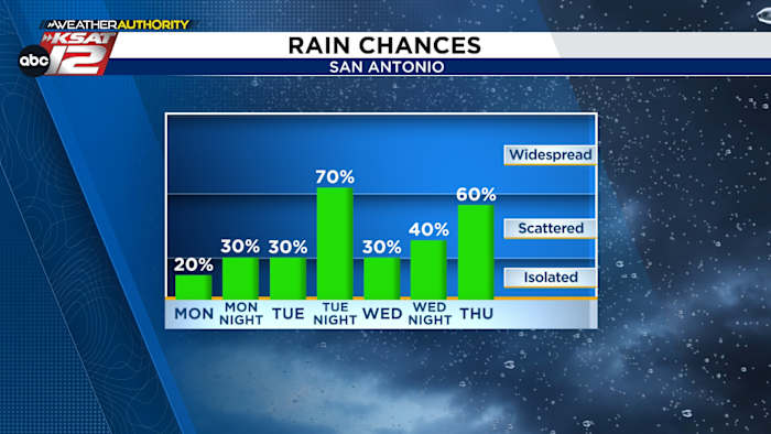
Temperatures will be warm this morning, as thick humidity and gusty winds will prevent any cooling. A few peeks of sun this afternoon should get temperatures to near 90. While a shower or storm can’t be ruled out, rain chances are generally low today.
TUESDAY
Tuesday plays out a lot like Monday. It’ll stay mostly quiet until after sunset. Then, a front will shift into the area from the northwest. This, along with the dryline, will kick off storms. These storms will develop into a line and push south, likely affecting the San Antonio area by midnight. Severe weather is possible. And while the storms will be moving fairly quickly, some street flooding will also be an issue.
WEDNESDAY AND BEYOND
The forecast gets a little more fuzzy starting Wednesday. Here’s what we know — the pattern stays active, we’ll have conditions for strong storms, and over time, rounds of heavy rain could result in street flooding. It’s just impossible to know exact timing and what areas these storms will affect. That includes for Memorial Day weekend. As soon as we get more clarity, we will pass that along to you.
Our advice: stay weather aware and check back often for updates!
QUICK WEATHER LINKS
Copyright 2026 by TheTXLoop – All rights reserved.