Storm chances return next week
FORECAST HIGHLIGHTS
-
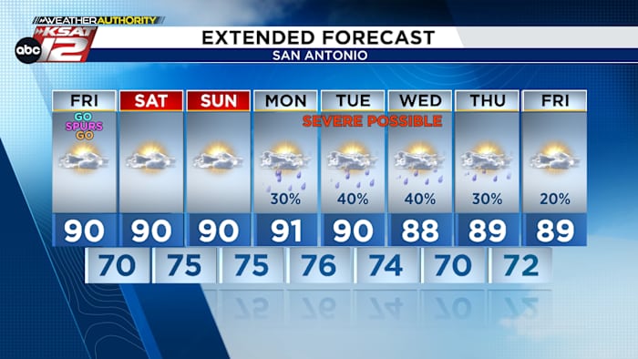
MORNING CLOUDS, PM SUN: Today through Sunday, highs near 90
-
STRAY STORM: Along Rio Grande this evening, stays west of SA
-
NEXT WEEK: Occasional storms, some strong
FORECAST
TODAY
After a brief round of morning clouds, we’ll see partly cloudy skies during the afternoon. It stays hot and we add humidity into the mix. Heat index values return to the forecast.
Meantime, a weak disturbance could stir up a storms in West Texas this afternoon. A few of these storms could make a run at places like Del Rio and Eagle Pass this evening. This activity should stay west of San Antonio.
WEEKEND
Morning cloud cover will last longer both Saturday and Sunday. Drizzle or a few sprinkles are possible Sunday morning. Otherwise, the afternoons will be warm and humid.
ACTIVE NEXT WEEK
The pattern becomes more active by Monday. Isolated storms are expected Monday evening. It’s impossible to know where a storm will pop up, but any storm that does will be capable of severe weather. By Tuesday, a weak front moving into North Texas will raise rain chances. Again, timing and placement of any storm is impossible to know at this point, but severe weather is a possibility. Beyond that, rain chances stay with us, potentially through Memorial Day weekend.
QUICK WEATHER LINKS
Copyright 2026 by TheTXLoop – All rights reserved.