First window for storm arrives tomorrow
FORECAST HIGHLIGHTS
-
FRONT #1 TOMORROW: Brings a window for storms, lowers humidity
-
FRONT #2 FRIDAY: Big cool-down for the weekend
-
WEEKEND: Low humidity – Mornings 50s – Afternoons 70s
FORECAST
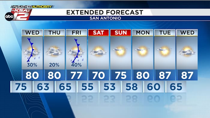
WEDNESDAY: FRONT #1
A front will arrive around midday. As it does, isolated storms will be possible along the boundary (10 am to 2 pm). Should storms develop, severe weather would be possible. Hail and gusty winds would be the main threats. Highest storm chances are in the Hill Country.
Temperatures will peak in the low-80s just before the front arrives. While the front won’t bring a big cool down, it does drop humidity levels a bit by Wednesday afternoon. Temperatures in the 60s are expected by Thursday morning.
FRIDAY: FRONT #2
After a fairly quiet day Thursday, a storm system will arrive from the west early on Friday. Unfortunately, our window for any rain will be quite small. A few showers and storms are possible Thursday night into early Friday morning. Highest rain totals will be across Central and North Texas.
The bigger story will be a strong front that will push through behind the system. In fact, on Saturday we’ll see a high of only 70, while morning lows will dip into the low-50s by Sunday morning!
QUICK WEATHER LINKS
Copyright 2026 by TheTXLoop – All rights reserved.