Some storms could be strong to severe this evening
FORECAST HIGHLIGHTS
-
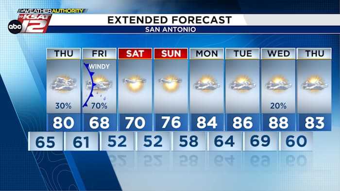
TONIGHT: A front kicks up isolated storms (30%), possibly severe
-
THURSDAY: Intermittent, isolated showers/storms (30%)
-
FRIDAY: Cool, showers and storms likely (60%), windy
-
WEEKEND: Cool mornings, beautiful afternoons
FORECAST
TONIGHT & TOMORROW
Isolated storms are likely this evening and tonight, and although coverage will be limited, they could become strong/severe with localized large hail and high wind gusts.
A cold front will slowly move through tonight and pretty much stall tomorrow, so intermittent and localized showers/storms are likely tomorrow. However, don’t expect much in terms of overall accumulation – it won’t be a washout.
FRIDAY
Friday will bring a variety of weather to the area. It’ll be cool with many spots struggling to get out of the 60s. Additionally, showers and storms will develop across South-Central Texas, with the best shot for rain being in the Hill Country and points northward. The farther north you go, the higher the rainfall totals. Some heavy rainfall and street flooding will be possible in these areas. Also know that northeast winds will gust as high as 35 mph. Cooler, drier weather will funnel into the area by Friday evening.
WEEKEND
Expect beautiful weather! Both Saturday and Sunday will start with lows in the 50s and afternoon highs in the 70s under mostly sunny skies.
QUICK WEATHER LINKS
Copyright 2026 by TheTXLoop – All rights reserved.